REG - Arc Minerals Limited - Mineralised Zone Extends to 300m Wide, 650m Long
20 August 2019
Arc Minerals Ltd
('Arc' or the 'Company')
Cheyeza East - Mineralised Zone Extends to over 300 Metres Wide and 650 Metres Long
Arc Minerals Limited is pleased to announce further drill results from its maiden exploration drill programme at the Cheyeza East target area in Zambia and an update on additional exploration activities at its high-priority West Lunga and Lumbeta targets.
Highlights:
Cheyeza East
· Width of mineralised zone extended to over 300m and remains open ended
· Strike length in the north has extended to at least 650m, also remaining open ended
· CHDDE006 intersected 19.70m at 0.59% Cu from 15.30m
o Includes 5.80m at 1.00% Cu from 27.70m
· CHDDE007 intersected 11m @ 0.75% Cu from 69.40m
o Includes 3.9m @ 1.42% Cu from 72.10m
· CHDDE009 intersected 9.00m @ 0.63% Cu from 11.90m
o Includes 5.00m @ 0.92% Cu from 14.90m
· Drilling programme progress continues positively and results of several drill holes to follow in near future
Additional targets
· Completed infill soil sampling at the Lumbeta target area has further refined the 11km long anomalous feature into three distinct target areas, the longest being 4km long.
· West Lunga target - access and initial drill pad preparation underway - definition of drill targets and drilling plans are well advanced.
Nick von Schirnding, Executive Chairman of Arc stated: "Drill holes six and seven, which were drilled either side of drill holes four and five, have demonstrated that the width of the mineralised zone along this drill profile is now in excess of 300m and still open ended.
Drill holes eight, nine, ten and twelve, drilled along strike and to the north east have confirmed that the strike length to the mineralised zone in the north of this target area is at least 650m long.
As the team on the ground continues to probe the Cheyeza East target area with coarse spaced drill holes to test the extent of the mineralised area, I am encouraged to see that the mineralisation encountered to date is still relatively shallow at generally less than 100m below surface.
The drilling programme thus far at Cheyeza East has been highly encouraging and continuing at pace. While we await the results of several new holes at Cheyeza East, investors should also look forward to maiden drilling at Lumbeta and West Lunga - two significant new targets which we are extremely excited by.
A third drill rig is now mobilising to the Lumbeta target area where over 3,700 infill soil samples have been collected and where soil geochemistry provides encouragement that the target area may be copper bearing. The largest of these zones is the western zone where the soil analysis can be traced for circa 4km and appears to represent the limbs of an interpreted anticline in this part of the license. We look forward to releasing further updates shortly."
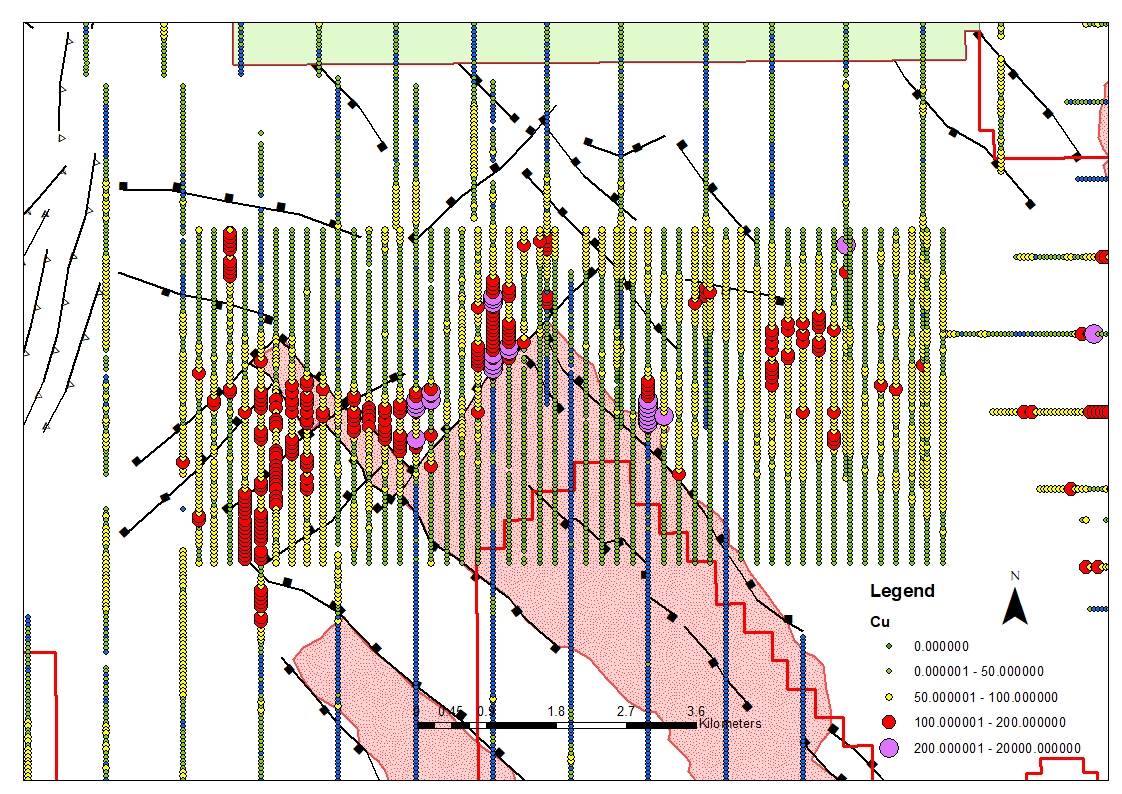
Figure 1. Map of the Cheyeza East target with the drill locations
http://s2.q4cdn.com/256050873/files/images/maps/2019-08-15-Cheyeza-East-Holes-Drilled.jpg
Drilling Results
The table below sets out the results of the holes for which assays have been received by Zamsort from SGS Inspection Service Ltd in Kalulushi, Zambia.
Table 1. Drilling Intercepts
Hole ID
From (m)
To (m)
Sample Width (m)
Cu (%)
CHDDE006
15.30
35.00
19.70
0.59
incl.
27.70
33.50
5.80
1.00
and
54.50
61.00
6.50
0.36
CHDDE007
18.90
20.90
2.00
0.32
69.40
80.40
11.00
0.75
incl.
72.10
76.00
3.90
1.42
CHDDE0008
3.40
16.90
13.50
0.30
72.30
79.40
7.10
0.31
CHDDE009
11.90
20.90
9.00
0.63
incl.
14.90
19.90
5.00
0.92
and
24.90
26.90
2.00
0.23
and
32.90
35.90
3.00
0.36
CHDDE010
8.27
14.50
6.23
0.26
21.00
23.15
2.15
0.22
42.68
48.50
5.82
0.51
incl.
44.75
47.00
2.25
0.79
CHDDE011
No Mineralised Intersection
CHDDE012
45.70
48.50
2.8m
1.00
Notes:
1) Reported intervals are downhole widths.
2) Reported intervals are calculated for zones assaying > 0.2% Copper and containing less than 3 metres of internal waste.
3) Metallurgical factors are assumed to be 100% although the recovery factors may vary significantly.
Drilling Summary
Drill hole CHDDE006 and CHDDE007 were drilled circa 100m on either side of drill holes CHDDE004 ('Hole 4') and CHDDE005 ('Hole 5') respectively. These holes were designed to test for the width of the mineralisation encountered along this drill profile and in particular the high grades of copper that were encountered in holes 4 & 5. Although lower in grade when compared to holes 4 & 5, these holes are still mineralised and demonstrate that the width of the mineralised zone along this profile is in excess of 300m.
Drill Holes CHDDE008 & CHDDE009 were drilled along the same profile as drill holes CHDDE002 ('Hole 2') & CHDDE003 (incomplete assays received to date). These holes were designed to test the extents of the mineralisation to the south west of Hole 2 and demonstrate that as above the mineralisation is still open ended along this drill profile.
Drill Holes CHDDE010 & CHDDE012 were drilled circa 350m along strike to the north west of the drill profile with holes 2, 3, 8 & 9 and demonstrate that the mineralisation is seemingly continuous across these three drill profiles in the northern part of the target area.
Drill Hole CHDDE011 is the first hole drilled in the southern part of the target area and did not appear to intersect any mineralisation of significance.
Cheyeza Target Area
The Cheyeza Target Area ('CTA') was one of several areas identified by both the geophysics and geochemistry work programmes completed last year. As reported on the 5th June 2019, of particular interest is a 3km by 0.8km area at Cheyeza East where up to 2,792 ppm copper in the soils has been identified and where these initial holes were drilled. Drilling continues at this anomaly to test its full extent, both along strike and down dip.
Lunbeta Target area - Infill Soils Summary
The 2019 exploration season commenced in March, initially over the Cheyeza Target Area ('CTA') and then moving across to the other target areas identified by the 2018 regional soil geochemistry and aerial geophysics programs.
The infill soil sampling programme over the key target areas was carried out and supervised by Zamsort's geological team. Over 3,700 samples were collected over the Lumbeta Target Area ('LTA') on a 200 x 50m grid and processed at the Kalaba Exploration camp, where the samples were dried, sieved and using a hand operated mechanical press, compressed into a pellet. The pressed pellets were subsequently analysed using a portable hand-held X-ray Fluorescence Spectrometer ('pXRF') for a range of elements, including copper and associated minerals.
The background copper values at the LTA range between 25 - 50ppm with values of up to 378ppm Cu being returned by the pXRF. The soil geochemistry provides encouragement that the LTA may be copper- bearing and that from the anomalous highs, the LTA may be divided into western, central and eastern zones. The largest of these zones is the western zone, where the soil analysis above 100ppm can be traced for circa 4km, and appears to represent the limbs of an interpreted anticline in this part of the license.
Figure 2. Image showing the Lumbeta target area and the results of the XRF analysis of the infill soil sampling completed earlier this year.
http://www.arcminerals.com/files/images/maps/lumbeta-target-area-xrf.jpg
Quality Assurance/Quality Control (QA/QC)
The core from the diamond core was sampled at up to 1.5m metre intervals with the split core (PQ - ¼ core; HQ - ¼ core) bagged and sent to SGS Inspection Service Ltd in Kalulushi, Zambia, an ISO accredited laboratory for assaying.
The samples were sorted, dried, crushed and pulped before final chemical analysis using ICP-OES methods. Standards, blanks and duplicates were inserted regularly in the sample stream and checks were done for copper and cobalt.
Qualified Persons
The information in this press release is based on information provided by Zamsort Limited on behalf of Arc Minerals. Mr Vassilios Carellas (BSc (Hons), MAusIMM) is the Chief Operating Officer for Arc Minerals and has sufficient experience relevant to the style of mineralisation and type of deposit under consideration and to the activity which he is undertaking to qualify as a Competent Person as defined under the JORC Code (2012). Mr Carellas consents to the inclusion in this announcement of the matters based on his information in the form and context in which it appears.
**ENDS**
Contacts
Arc Minerals Ltd
Nick von Schirnding (Chairman)
+44 (0) 20 7917 2942
SP Angel (Nominated Adviser & Broker)
Ewan Leggat / Soltan Tagiev
+44 (0) 20 3470 0470
Market Abuse Regulation (MAR) Disclosure
Certain information contained in this announcement would have been deemed inside information for the purposes of Article 7 of Regulation (EU) No 596/2014 until the release of this announcement.
Forward-looking Statements
This news release contains forward-looking statements that are based on the Company's current expectations and estimates. Forward-looking statements are frequently characterised by words such as "plan", "expect", "project", "intend", "believe", "anticipate", "estimate", "suggest", "indicate" and other similar words or statements that certain events or conditions "may" or "will" occur. Such forward-looking statements involve known and unknown risks, uncertainties and other factors that could cause actual events or results to differ materially from estimated or anticipated events or results implied or expressed in such forward-looking statements. Such factors include, among others: the actual results of current exploration activities; conclusions of economic evaluations; changes in project parameters as plans continue to be refined; possible variations in ore grade or recovery rates; accidents, labour disputes and other risks of the mining industry; delays in obtaining governmental approvals or financing; and fluctuations in metal prices. There may be other factors that cause actions, events or results not to be as anticipated, estimated or intended. Any forward-looking statement speaks only as of the date on which it is made and, except as may be required by applicable securities laws, the Company disclaims any intent or obligation to update any forward-looking statement, whether as a result of new information, future events or results or otherwise. Forward-looking statements are not guarantees of future performance and accordingly undue reliance should not be put on such statements due to the inherent uncertainty therein.
Notes to the Editors
Arc Minerals is an AIM listed exploration and mine development company focused on a diversified portfolio of mining projects with interests in Slovakia, Eritrea, the Democratic Republic of the Congo and Zambia.
ARC Minerals current holdings include:
● 100% interest in CASA Mining Limited, a private company that has a 71.25% interest in the 3-million-ounce inferred Resource Akyanga gold deposit in the DRC.
● A 66% equity interest in Zamsort Limited ("Zamsort"), a private company focused on a prospective copper t licence in the Zambia Copperbelt, together with a convertible loan to Zamsort which converts into approximately a five percent additional equity interest in Zamsort.
● A 47.5% equity interest in Zaco Limited ("Zaco"), a private company focussed on a prospective copper and cobalt license adjacent to Zamsort.
● 100% ownership of the Kremnica Mining Licence Area in Slovakia which host the 1.3Moz AuEq Au PFS stage Ṧturec Gold Project.
For more information visit www.arcminerals.com
Glossary of Technical Terms
"anomaly or anomalous"
something in mineral exploration that geologists interpret as deviating from what is standard, normal, or expected.
"assay"The laboratory test conducted to determine the proportion of a mineral within a rock or other material. For copper, usually reported as percentage which is equivalent to percentage of the mineral (i.e. copper) per tonne of rock.
"azimuth"
the "compass direction" refers to a geographic bearing or azimuth as measured by a magnetic compass, in true or magnetic north.
"bornite"
Bornite, also known as peacock ore, is a copper sulphide mineral with the formula Cu5FeS4.
"breccia"
Breccia is a rock classification, comprises millimetre to metre-scale rock fragments cemented together in a matrix, there are many sub-classifications of breccias.
"chalcocite"
Chalcocite is a copper sulphide mineral with the formula Cu2S and is an important copper ore mineral. It is opaque and dark-gray to black with a metallic luster.
"chalcopyrite"
Chalcopyrite is a copper sulphide mineral with formula CuFeS2. It has a brassy to golden yellow colour.
"chargeability"
Chargeability is a physical property related to conductivity. Chargeability is used to characterise the formation and strength of the induced polarisation within a rock, under the influence of an electric field, suggesting sulphide mineralisation at depth.
"covellite"
Covellite is a copper sulphide mineral with the formula CuS. This indigo blue mineral is ubiquitous in some copper ores.
"diamond drilling"
A drilling method in which penetration is achieved through abrasive cutting by rotation of a diamond encrusted drill bit. This drilling method enables collection of tubes of intact rock (core) and when successful gives the best possible quality samples for description, sampling and analysis of an ore body or mineralised structure.
"dip"
A line directed down the steepest axis of a planar structure including a planar ore body or zone of mineralisation. The dip has a measurable direction and inclination from horizontal.
"grab sample"
are samples of rock material collected from a small area, often just a few pieces or even a single piece of rock "grabbed" from a face, dump or outcrop or roughly 2-5kg. These are common types of rock samples collected when conducting mineral exploration. The sample usually consists of material that is taken to be representative of a specific type of rock or mineralisation.
"grade"
The proportion of a mineral within a rock or other material. For copper mineralisation this is usually reported as % of copper per tonne of rock.
"g/t"
grams per tonne; equivalent to parts per million ('ppm')
"hematite"
Hematite is the mineral form of iron(III) oxide (Fe2O3), one of several iron oxides. Magnetite alteration is also typically associate with porphyry copper systems, at or close to the central core.
"Indicated Resource"
An "Indicated Mineral Resource" is that part of a Mineral Resource for which quantity, grade or quality, densities, shape and physical characteristics, can be estimated with a level of confidence sufficient to allow the appropriate application of technical and economic parameters, to support mine planning and evaluation of the economic viability of the deposit. The estimate is based on detailed and reliable exploration and testing information gathered through appropriate techniques from locations such as outcrops, trenches, pits, workings and drill holes that are spaced closely enough for geological and grade continuity to be reasonably assumed.
"Inferred Resource"
An "Inferred Mineral Resource" is that part of a Mineral Resource for which quantity and grade or quality can be estimated on the basis of geological evidence and limited sampling and reasonably assumed, but not verified, geological and grade continuity. The estimate is based on limited information and sampling gathered through appropriate techniques from locations such as outcrops, trenches, pits, workings and drill holes.
"Induced Polarisation Geophysics"
Induced polarisation (IP) is a geophysical survey used to identify the electrical chargeability of subsurface materials, such as sulphides. The survey involves an electric current that is transmitted into the subsurface through two electrodes, and voltage is monitored through two other electrodes.
"intercept"
Refers to a sample or sequence of samples taken across the entire width or an ore body or mineralised zone. The intercept is described by the entire thickness and the average grade of mineralisation.
"JORC Code"
The Australasian Code for Reporting of Exploration Results, Mineral Resources and Ore Reserves ('the JORC Code') is a professional code of practice that sets minimum standards for Public Reporting of minerals Exploration Results, Mineral Resources and Ore Reserves.
"K"
The element potassium, abundance on surface can be inferred from radiometric surveys
"Magnetics"
Rocks are made up of different minerals and the magnetic properties of a rock depends on the amount and type of iron rich minerals it contains. Earth's magnetic field interacts with these iron rich minerals to generate variations in the magnetic field. Measuring and mapping these variations allows remotely mapping of the distribution and patterns of magnetic rocks and, as a result, map the subsurface geology
"magnetite"
Magnetite is main iron ore mineral, with chemical formula Fe3O4. Magnetite is ferromagnetic, and it is attracted to a magnet and can be magnetized to become a permanent magnet itself.
"massive"
In a geological sense, refers to a zone of mineralisation that is dominated by sulphide minerals. The sulphide-mineral-rich material can occur in centimetre-scale, metre-scale or in tens of metres wide veins, lenses or sheet-like bodies containing sphalerite, galena, and / or chalcopyrite etc.
"Measured Resource"
A "Measured Mineral Resource" is that part of a Mineral Resource for which quantity, grade or quality, densities, shape, and physical characteristics are so well established that they can be estimated with confidence sufficient to allow the appropriate application of technical and economic parameters, to support production planning and evaluation of the economic viability of the deposit. The estimate is based on detailed and reliable exploration, sampling and testing information gathered through appropriate techniques from locations such as outcrops, trenches, pits, workings and drill holes that are spaced closely enough to confirm both geological and grade continuity.
"Mineral Resource"
A "Mineral Resource" is a concentration or occurrence of diamonds, natural solid inorganic material, or natural solid fossilised organic material including base and precious metals, coal, and industrial minerals in or on the Earth's crust in such form and quantity and of such a grade or quality that it has reasonable prospects for economic extraction. The location, quantity, grade, geological characteristics and continuity of a Mineral Resource are known, estimated or interpreted from specific geological evidence and knowledge.
"mineralisation"
In geology, mineralisation is the deposition of economically important metals (copper, gold, lead, zin etc) that in some cases can be in sufficient quantity to form mineral ore bodies.
"open pit mining"
A method of extracting minerals from the earth by excavating downwards from the surface such that the ore is extracted in the open air (as opposed to underground mining).
"outcrop"
A section of a rock formation or mineral vein that appears at the surface of the earth. Geologists take direct observations and samples from outcrops, used in geologic analysis and creating geologic maps. In situ (in place) measurements are critical for proper analysis of the geology and mineralisation of the area under investigation.
"polymict"
A geology term, often applied to breccias or conglomerates, which identifies the composition as consisting of fragments of several different rock types.
"Preliminary Economic Assessment"
NI 43-101 defines a PEA as "a study, other than a pre-feasibility study or feasibility study, which includes an economic analysis of the potential viability of mineral resources".
"Pyrrhotite"
Pyrrhotite is an iron sulfide mineral with the formula Fe(1-x)S (x = 0 to 0.2). It is a nonstoichiometric variant of FeS, the mineral known as troilite. Pyrrhotite is also called magnetic pyrite
"Radiometrics"
The radiometric, or gamma-ray spectrometric method is a geophysical process used to estimate concentrations of the radioelements potassium, uranium and thorium by measuring the gamma-rays which the radioactive isotopes of these elements emit during radioactive decay
"sediments"
Sedimentary rocks formed by the accumulation of sediments. There are three types, Clastic, Chemical and Organic sedimentary rocks.
"sphalerite"
Sphalerite is a zinc sulphide in crystalline form but almost always contains variable iron, with formula (Zn,Fe)S. It can have a yellowish to honey brown or black colour.
"supergene"
Supergene ore processes occur near surface, and form deposits of secondary minerals, such as malachite, azurite, chalcocite, covellite, digenite, etc.
"surface rock chip samples"
Rock chip samples approximately 2kg in size that are typically collected from surface outcrops exposed along rivers and mountain ridgelines.
"Th"
The element thorium, abundance on surface can be inferred from radiometric surveys
"U"
The element uranium, abundance on surface can be inferred from radiometric surveys
"veins"
A vein is a sheet-like or anastomosing fracture that has been infilled with mineral ore (chalcopyrite, covellite etc) or mineral gangue (quartz, calcite etc) material, within a rock. Veins form when minerals carried by an aqueous solution within the rock mass are deposited through precipitation and infill or coat the fracture faces.
"volcanics"
Volcanic rock such as andesite or basalt that is formed from magma erupted from a volcano, or hot clastic material that erupts from a volcano and is deposited as volcaniclastic or pyroclastics.
This information is provided by RNS, the news service of the London Stock Exchange. RNS is approved by the Financial Conduct Authority to act as a Primary Information Provider in the United Kingdom. Terms and conditions relating to the use and distribution of this information may apply. For further information, please contact rns@lseg.com or visit www.rns.com.ENDDRLGGUQPRUPBGBB
Recent news on ARC Minerals
See all newsREG - Arc Minerals Limited - Commencement of Geophysical Programme in Botswana
AnnouncementRCS - Arc Minerals Limited - Investor Presentation via Investor Meet Company
AnnouncementREG - Arc Minerals Limited - Management Change
AnnouncementREG - Arc Minerals Limited - Zambia Legal Update
AnnouncementREG - Arc Minerals Limited - Avanti Settlement Received
Announcement