Gorge Project – Initial Results - Airborne Surveys
17 June 2026
GEO Exploration Limited
("GEO " or the "Company")
Gorge Project - Initial Results - Airborne Geophysical Surveys
Key Initial Highlights
· New high-priority MAG001 target identified - a strike-limited magnetic anomaly has been identified in the northwest of the tenement, with 3D inversion modelling indicating a depth to top of approximately 300m beneath surface and significant vertical extent.
· Multiple datasets support MAG001 - the magnetic anomaly is coincident with a LiDAR-defined topographic anomaly and iron-oxide staining observed at surface, a combination considered encouraging and potentially consistent with features observed in certain intrusion-related gold systems.
· Approximately 5km gold trend better defined - magnetic data has improved the definition of the previously recognised trend of historical gold mineralisation and workings, now interpreted as a major northeast-trending structural zone.
· Potential hydrothermal fluid-flow system identified - areas of demagnetisation along the interpreted structural zone may potentially indicate hydrothermal fluid flow associated with a significant gold system.
· New radiometric anomalies identified - two significant uranium anomalies, RAD001 and RAD002, have been identified proximal to the known gold trend, with RAD001 located approximately 300m from MAG001.
GEO Exploration Limited (AIM: GEO) is pleased to announce the initial results from airborne geophysical surveys collected over the Gorge Project in Western Australia.
The programme comprised high-resolution LiDAR, aerial photography, magnetic and radiometric surveys over the Gorge Project licence area. The survey work was completed safely and ahead of schedule, with the initial results identifying new priority targets and materially improving GEO's understanding of the Project's geology, structure, historical workings and potential controls on mineralisation.
LIDAR and Aerial Photography Survey Results
The high-resolution LiDAR and aerial photography survey was completed over the full Gorge Project licence area by Aerometrex Ltd ahead of schedule.
LiDAR is a high-precision remote sensing method that uses laser pulses to generate high-resolution and detailed three-dimensional digital terrain model (DTM) of surface topography.
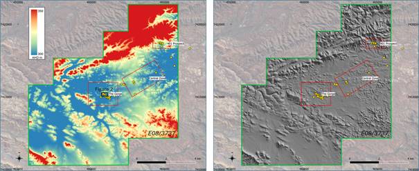
The results have materially improved GEO's ability to identify and map key surface features across the Project, including historic workings, shafts, geological outcrops, access tracks and local topography. Figure 1 shows the LiDAR-derived digital terrain model across the Project area, including target areas, historical workings and the tenement outline, providing a significantly improved surface dataset for geological and logistical planning.
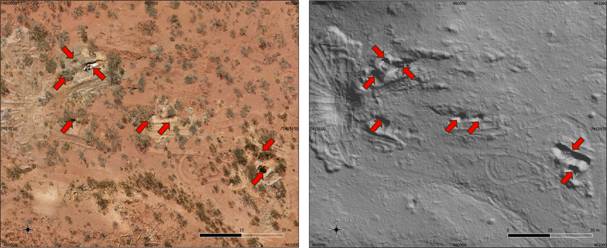
At the Gorge West area, the benefits of the new dataset are particularly clear. Figure 2 shows how the aerial photography and LiDAR-derived terrain model enable clearer identification of historic shafts and workings, providing important information for follow-up mapping, access planning and future drill preparation.
This information will be integrated with the magnetic, radiometric and field datasets to assist geological interpretation, target generation and planning for the proposed maiden drilling programme.
Figure 1 - LIDAR DTM results with target areas, historical workings and tenement outline.
(Left) pseudo colour (Right) grey scale with sun shading. Plan view.
Figure 2 - Gorge West mining area, historic shafts shown by red arrows
(Left) Aerial Photography (Right) DTM grey scale. Plan view.
Magnetic and Radiometric Survey Results
The airborne magnetic survey was completed over the full Gorge Project licence area ahead of schedule. The results are being used to improve GEO's understanding of the Project's geology, structure and potential controls on mineralisation.
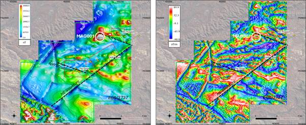
Initial interpretation of the magnetic data has improved the definition of the previously recognised approximately 5km trend of historical gold mineralisation and workings. This trend is now interpreted as a major northeast-trending structural zone, with areas of demagnetisation that may potentially be indicative of hydrothermal fluid flow associated with a significant gold system.
The mineralised gold trend is also interpreted to be offset by later northwest-trending structures. The intersection of these significant structures may represent important controls on gold mineralisation. Figure 3 shows the magnetic survey results across the Project area, including the target areas, historical workings and tenement outline.
Figure 3 - Magnetic survey results with target areas, historical workings and tenement outline.
(Left) RTP image (Right) Tilt Derivative image. Plan view.
Priority Magnetic and Radiometric Anomalies
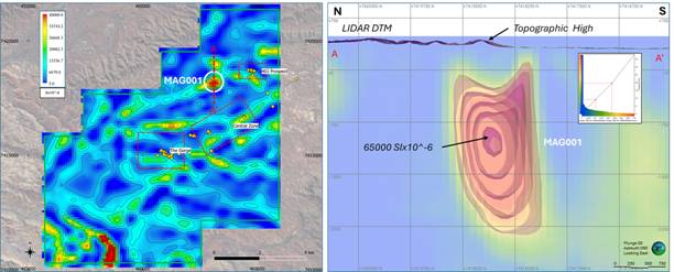
The airborne survey has identified a new high-priority magnetic anomaly, MAG001, in the northwest of the tenement. The anomaly is strike-limited, has an amplitude of approximately 400nT, and 3D inversion modelling indicates a depth to top of approximately 300m beneath surface with significant vertical extent.
Importantly, MAG001 is coincident with a topographic anomaly identified from the recently completed LiDAR and aerial photography survey, with iron-oxide staining also observed at surface. This combination of magnetic, topographic and surface alteration features is considered encouraging and may be consistent with features observed in certain intrusion-related gold systems, including the style of target GEO is actively evaluating at its Juno Project.
Figure 4 shows the magnetic depth-slice and 3D inversion model for MAG001, which will now be assessed as part of the ongoing target refinement work.
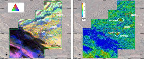
In addition, interpretation of the radiometric data has identified two significant uranium anomalies, RAD001 and RAD002, located proximal to the known gold trend. RAD001 is located approximately 300m from MAG001, providing a further area of interest for follow-up evaluation.
The combination of magnetic and radiometric signatures is considered encouraging and may be consistent with features observed in certain Iron-Oxide-Copper-Gold (IOCG) systems, including deposits such as Carapateena, Olympic Dam and Ernest Henry. Figure 5 shows the radiometric survey results, including the RGB ternary image and uranium channel image across the Project area.
These magnetic, radiometric and topographic features will be integrated with the LiDAR, aerial photography, soil geochemistry and geological mapping datasets to assist GEO in ranking and refining priority targets for the proposed maiden drilling programme.
Figure 4 - Magnetic survey results with target areas, historical workings and tenement outline. (left) 500m Depth Slice image. Plan View. (right) 3D magnetic inversion isosurfaces & block model. Section View. Looking East. VE1.
Figure 5 - Radiometric survey results with target areas, historical workings and tenement outline.
(Left) RGB ternary image (Right) Uranium channel image. Plan View.
Airborne Geophysical Data Interpretation Forward Programme
The airborne geophysical datasets are now being integrated into GEO's broader technical work programme for the Gorge Project. GEO is pleased to advise that Dr Finbarr 'Barry' Murphy (Fractore Pty Ltd) has been engaged to support the GEO's technical team in completing a detailed litho-structural interpretation of the airborne magnetic, radiometric, LiDAR and aerial photography datasets.
This work is expected to assist in refining the understanding of structural controls on mineralisation, improving geological mapping, and identifying, ranking and prioritising target areas for follow-up exploration. The results of this interpretation work will be combined with planned soil geochemistry and geological mapping to support target refinement and planning for the proposed maiden drilling programme. Drilling activities remain subject to completion of the required heritage and government permitting processes.
Tom Harris, GEO's Exploration Manager, commented:
"The team and I wish to thank all contractors involved in the safe and timely delivery of the airborne geophysical surveys at Gorge. The initial results have already shown tremendous value with the identification of not only unrecognised historic workings, but high priority magnetic and radiometric targets. I am excited to see the results of interpretation work, soil geochemical and geological mapping over these new exciting targets."
Omar Ahmad, Chief Executive Officer, commented:
"We are very pleased with the progress being made at Gorge Project. The airborne survey programme has been completed safely and ahead of schedule, and the initial results are already providing valuable new insight into the structure, geology and target potential of the Project.
The modern datasets now being generated are helping us move from historical prospectivity towards systematic target generation. With several aspects of the current work programme progressing ahead of schedule, GEO is focused on maintaining momentum through interpretation, soil geochemistry, geological mapping and target refinement.
Our objective is to build a strong technical case for priority drill targets as we advance Gorge Project towards its proposed maiden drilling programme."
Gorge Project Overview
The Gorge Project (Exploration Licence E08/3737), located approximately 110km west of Paraburdoo in Western Australia, covers an area of 81 square kilometres within the Proterozoic aged Capricorn Orogen. GEO recently acquired the licence, through its 100% owned subsidiary Gorge Gold Pty Ltd. The Gorge project is considered highly prospective for large scale gold systems of Orogenic-type or Carlin-type.
Limited historical exploration at Gorge has identified widespread gold mineralisation across the licence area. Gold occurrences have been recorded over approximately 5km of strike, supported by drainage, soil and rock chip sampling, historic workings, and alluvial and eluvial gold mining.
Historical results include:
· Rock chip samples returning gold values up to 134g/t Au
· Soil samples returning gold values up to 233g/t Au
· Drainage sampling returning elevated gold values
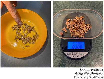
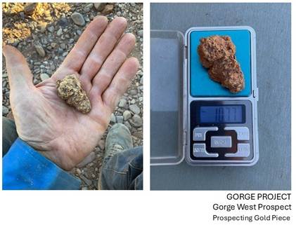
· Recovery of multiple gold nuggets from near surface, ranging from <2g to in excess of 100g
These results along with the proximity of the nugget recoveries suggests the potential presence of a primary bedrock gold source within the licence area.
Figure 6 - Gorge West Prospect. Historic examples of Gold Nuggets Collected from Near Surface
Figure 7 - Gorge West Prospect. Historic Gold Nugget Collected from Near Surface
The information contained within this announcement is deemed by the Company to constitute inside information under the UK Market Abuse Regulations ("MAR"). Upon the publication of this announcement via a Regulatory Information Service ("RIS"), this inside information is now considered to be in the public domain.
Competent Person - The information in this announcement relating to the project is deemed to be a true representation of exploration results. Mr Steven Andrew Milner has sufficient experience, to qualify as a Competent Person as defined in the 2012 Edition of the Joint Ore Reserves Committee (JORC) "Australasian Code for Reporting of Exploration Results, Mineral Resources and Ore Reserves". Steven is a member of the Australasian Institute of Mining and Metallurgy (M.Aus.lMM #109255), is employed as a consultant with Austwide Mining Title Management Pty Ltd and is a graduate of Durham University and has over 40 years of experience in exploration and mining in Australia, Zimbabwe and Namibia. Steven is a Director of Mineral Search Pty Ltd.
For further information please visit: www.geoexplorationlimited.com or contact:
GEO Exploration Limited
Hamza Choudhry, CFO and Executive Director
investors@geoexpltd.com
SPARK Advisory Partners Limited (Nominated Adviser)
Andrew Emmott, Dillon Wall
+44 (0) 20 3368 3555
CMC Markets (Joint Broker)
Douglas Crippen
+44 (0) 20 3003 8632
SI Capital Limited (Joint Broker)
Nick Emerson
+44 (0) 14 8341 3500
Follow us on social media
The person responsible for the release of this announcement is Hamza Choudhry, Chief Financial Officer and Executive Director.
This information is provided by RNS, the news service of the London Stock Exchange. RNS is approved by the Financial Conduct Authority to act as a Primary Information Provider in the United Kingdom. Terms and conditions relating to the use and distribution of this information may apply. For further information, please contact rns@lseg.com or visit www.rns.com.
RNS may use your IP address to confirm compliance with the terms and conditions, to analyse how you engage with the information contained in this communication, and to share such analysis on an anonymised basis with others as part of our commercial services. For further information about how RNS and the London Stock Exchange use the personal data you provide us, please see our Privacy Policy.ENDUPDEAXKKFEKKEFA